For me, hiking is about the journey rather than the destination, and the reward is in summiting or completing the journey. But that’s not true of every hiker. I’ve plenty of hiking buddies who won’t sweat it out for anything less than a peak with a view from the top. If that sounds like you, then set your Waze for PD and make towards Bukit Batu Putih.
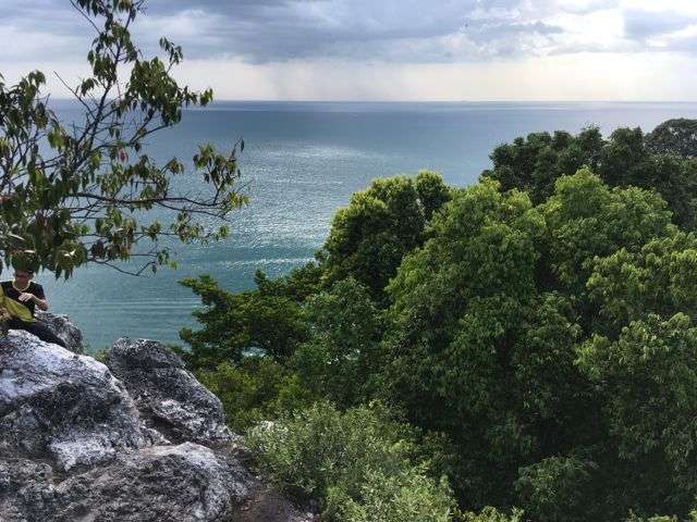
For views alone, Bukit Batu Putih should top your list. Part of a 200 million year old quartz ridge, this promontory is surrounded by one of the country’s last remaining coastal rainforests, has near pristine blue bays to either side of it, and the straits in front of it stretching for miles until it fades out of sight.
The other reason to visit Bukit Batu Putih is its accessibility. Technically in Melaka it is located on the fringes of Port Dickson in Negeri Sembilan, and as hikes go it’s a short one regardless of which route you choose: beach or forest.

Although both start from within Tanjung Tuan Forest Reserve, the forest route is the shortest and easiest, taking no more than 40 minutes, and starts further up the tarmac road, just under the lighthouse.

At one hour or so, the beach route is longer and harder though considerably more dramatic. Exiting the tarmac road earlier on, it takes you through the forest down towards the beautiful and deserted Monkey Bay, where you’ll get a flash of the hill’s stony white length peeking out from under the lush green of the scrub. You’ll then have to make your way toward its peak via a steep jungle trail which is passable only during low tide, so checking the tides in advance is a must. The currents here are known to be strong so swimming or wading it may not be an option.
Forest trail

Here during Malaysian Nature Society‘s annual Raptor Watch event, I didn’t have much time to spare so I chose the forest route.
After a steep but short 15 to 20 minute slog up the tarmac road that winds its way up from the entrance of Tanjung Tuan Recreational Forest, the trailhead is on the right, just about 30 or so meters short of the stairs leading to the historical Cape Rachado lighthouse. It’s signposted (see image) so you can’t miss it.
There’s another trail next to it heading down. I didn’t explore it but I presume takes you down to one of the beaches.


After a quick scramble up the embankment, the trail very briefly takes you up before flattening out. It’s wide and well trodden so you needn’t worry about getting lost.
Five minutes later the path will slope downwards, while tell tale white rocks will soon signal you’re close by. In fact less than 15 minutes from the trailhead, you’ll be at the foot of a rocky outcrop.


Despite what I’ve seen in YouTube videos, the final stretch to the peak, a climb up the very rocks from which Bukit Batu Putih gets its name, is neither long and treacherous (perhaps if you climbed up it’s craggy face from sea level up). From the forest route approach its 5 metres up this jagged crevasse. Coming down is a little trickier but there’s a rope you can use to rappel your way down.

Alternatively you can swing round the left of the rocky outcrop and take a hard right at the rope up one of two ways to the top. This too requires some rock climbing.


The laminated paper sign at the apex puts Bukit Batu Putih at 285 meters above sea level. I have serious doubts about this, nevertheless it’s impossible not to be enthralled by the view.
If it weren’t for the crowd, which swells in size in the morning when its cooler and in the evening just before sunset, I could have easily sat there listening to the lazy drone of speedboats, drinking in the sea breeze and soaking up the last golden rays of the sun.


I do stay long enough to watch a stream of Oriental Honey Buzzards soar above me, circle, then make their way northwards in the direction of Port Dickson. Not everyone is in the right place at the right time to be able to.
Part of a twice annual migration of birds of prey whose flight pattern takes them down South to Australia for the winter and back up north to China and Russia to feed and nest during the summer, they arrive here during the months of March and April after a 38 kilometres journey across the straits of Melaka from Pulau Rupat on Sumatra. While Cape Rachado lighthouse is one of the best places to view this spectacle, it’s usually inundated with birdwatchers and photographers with lengthy camera lenses, making Bukit Batu Putih the next best vantage point from which to take in this amazing sight.
Tanjung Tuan Recreational Forest gate to trailhead 20 minutes.
Trailhead to rocky outcrop and peak 10 to 15 minutes.
Altitude 74 meters.
Time 35 minutes one way.
Rating Easy with a little rock climbing towards the end, not suitable for children under 6 years of age.
Facilities Toilets are located near the entrance to Tanjung Tuan Recreational Forest and parking is available next to PNB Ilham Resort. At the weekends ice cream vendors congregate at the park entrance, while drinks are sometimes sold at the lighthouse steps.
Admission RM1. Tanjung Tuan Recreational Forest is open daily from 7am to 6pm.
Getting there Chart a course for Tanjung Tuan Recreation Forest or PNB Ilham Resort.
Coordinates 2.412603, 101.855564
Share this:
Like this:
Like
Loading…
Related
As a permanent forest reserve, a section of Tanjung Tuan Recreational Forest has also been gazetted as a Wildlife and Bird Sanctuary (60.70 hectares) since 1971. While the forest is connected to the land of Negeri Sembilan, the area is actually under the state of Malacca. Due to its proximity to Port Dickson, many refer to the popular hiking spot as Bukit Batu Putih Port Dickson.
Tanjung Tuan Recreation Forest is open to visitors daily from 7am to 6pm. Entrance fee to the forest reserve is RM1 and to be paid at the counter, no advance permit booking required.
One of the many attractions of Tanjung Tuan Forest is, of course, the hike to Bukit Batu Putih, which we will cover below. Other than that, there are more trails and beaches to explore around the forest reserve and I will guide you for the loop trails. Lastly, visitors who do not wish to hike the forest trails can walk up the tarmac road to Cape Rachado Lighthouse.
Just past the gate, there is a small building where visitors have to pay an entrance fee of RM1 per person. A nearby stall sells drinks and snacks, although it might not be open very early in the morning. This is also your last chance to use the toilet, as there aren’t any other on the trail.
From the entrance, you will have to walk uphill on a winding tarmac road that leads all the way up to the Cape Rachado Lighthouse. There are sheds with benches along the way if you need to take a break.

Although the road is sheltered by the trees, it is quite steep and is probably the most taxing part of the hike.
To get to the peak of Bukit Batu Putih, you have two choices of routes: the beach or forest trail. If you choose the beach trail, you will exit the tarmac road earlier on. This route is longer (taking about an hour or so) and harder.
It first takes you through the forest down towards the Monkey Bay (yes, there might be monkeys). After that, you’ll have to make your way up to the peak via a steep jungle trail that is only passable during low tide. At high tide, the current can be strong and dangerous, so make sure you check before going.
The forest route, on the other hand, is shorter and easier. For all the three times I hiked Bukit Batu Putih, I chose the forest route because my main goal when hiking is to reach the summit, and I’d rather get there sooner than later.
The start of the forest trail is further up the tarmac road (about 20 minutes from the gate), just before the lighthouse. It’s signposted, so you can’t miss it.

Here, it’s a bit steep and may require you to scramble on all fours if you’re not much of an athlete. But don’t let that intimidate you — the trail is not going to be like that all the way. Soon after, it levels out into a wide and well-trodden path.
As you walk on, you will hear and catch glimpses of the sea, which tells you that you’re near.

Just before you reach the final stretch, the path will slope downwards, and in less than 15 minutes from the trailhead, you should reach the foot of a white rocky outcrop that will take you to the summit. This is what gives Bukit Batu Putih (White Rock Hill) its name.
Some rock climbing skills would be beneficial here, but it’s not particularly hard for someone of average fitness level. Although there’s a rope tethered to the top to help you climb up and down, I’m not sure how long it has been there or how often it’s replaced, so use it at your own risk.

Once you reach the peak at 285 metres above sea level, you’ll be glad you woke up early for this. The view overlooking the Straits of Malacca is possibly one of the most impressive summit views in Malaysia.